Property Record
1909 N Unknown Dr, Merritt Island, FL 32952
NEARBY LISTINGS FOR SALE OR LEASE
Property Detail
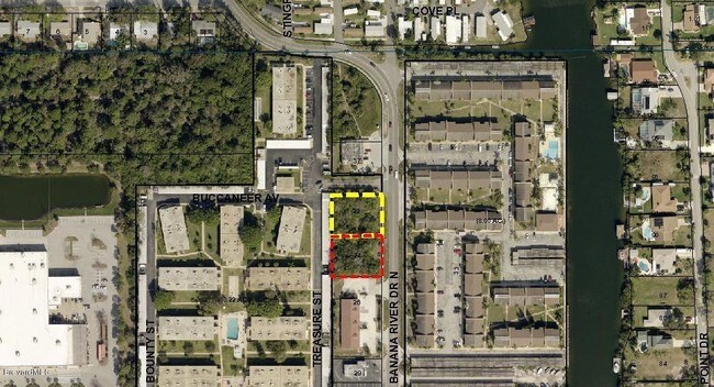
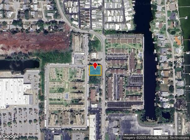
1909 N Unknown Dr
Palm Bay-Melbourne-Titusville, FL
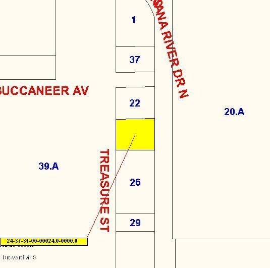
S 105 FT OF N 467.29 FT OF E 128 FT OF W 778 FT OF GOVT LOT 1 AS DESC IN ORB 3227 PG 2599 EXC ORB 3308 PG 2787, 3390 PG 2517 PAR 23
24-37-31-00-00022.0-0000.00
Brevard
Commercialacreage
Florida
AE
1
12009C0435H
0.31 AC
2024
Brevard County
2025
Orlando
069400
DEMOGRAPHICS near 1909 N Unknown Dr
1 Mile
3 Mile
5 Mile
2024 Total Population
4,019
26,157
80,815
2029 Population
4,392
28,475
89,445
Pop Growth 2024-2029
+ 9.28%
+ 8.86%
+ 10.68%
Average Age
47
47
48
2024 Total Households
1,900
11,820
38,555
HH Growth 2024-2029
+ 9.11%
+ 8.90%
+ 10.95%
Median Household Inc
$69,612
$69,964
$68,870
Avg Household Size
2.10
2.10
2.00
2024 Avg HH Vehicles
2.00
2.00
2.00
Median Home Value
$301,122
$334,771
$339,305
Median Year Built
1967
1969
1976
Nearby Places
Map Layers
Map Styles
 Street
 Aerial
- Restaurants
- Banks
- Shops
- Fitness
- Groceries
PUBLIC TRANSPORTATION
AIRPORT
Melbourne Orlando International
DRIVE
WALK
Distance
Melbourne Orlando International
46 min
25.9 mi
Orlando International
DRIVE
WALK
Distance
Orlando International
49 min
45.9 mi
SALE & LEASE HISTORY
LISTING DATE
SALE/LEASE

Sep 24, 2016
For Sale
Mar 29, 2017
For Sale
Nearby Properties
Address
Land Use
TOTAL SIZE
Lot Size
Zoning
Address
Land Use
TOTAL SIZE
Lot Size
Zoning
320,279 SF
51.92 AC
PS1
Address
Land Use
TOTAL SIZE
Lot Size
Zoning
256,094 SF
37.37 AC
BU1
Address
Land Use
TOTAL SIZE
Lot Size
Zoning
263,066 SF
13.36 AC
PUD
Address
Land Use
TOTAL SIZE
Lot Size
Zoning
211,483 SF
14.46 AC
BU2
Address
Land Use
TOTAL SIZE
Lot Size
Zoning
313,612 SF
11.91 AC
BU1
Address
Land Use
TOTAL SIZE
Lot Size
Zoning
666,224 SF
55.06 AC
BU1
Address
Land Use
TOTAL SIZE
Lot Size
Zoning
212,232 SF
20.80 AC
RU215
Address
Land Use
TOTAL SIZE
Lot Size
Zoning
153,136 SF
8.65 AC
RU215
Address
Land Use
TOTAL SIZE
Lot Size
Zoning
198,201 SF
26.18 AC
BU1
Address
Land Use
TOTAL SIZE
Lot Size
Zoning
122,116 SF
28.56 AC
AU
Address
Land Use
TOTAL SIZE
Lot Size
Zoning
140,113 SF
25 AC
GU
Address
Land Use
TOTAL SIZE
Lot Size
Zoning
249,080 SF
106.95 AC
GML
Address
Land Use
TOTAL SIZE
Lot Size
Zoning
120,495 SF
3.86 AC
PUD
Address
Land Use
TOTAL SIZE
Lot Size
Zoning
98,877 SF
7.86 AC
BU2
Address
Land Use
TOTAL SIZE
Lot Size
Zoning
89,408 SF
18.50 AC
GU
Address
Land Use
TOTAL SIZE
Lot Size
Zoning
84,747 SF
8.57 AC
BU2
Address
Land Use
TOTAL SIZE
Lot Size
Zoning
83,650 SF
25.65 AC
AU
Address
Land Use
TOTAL SIZE
Lot Size
Zoning
97,920 SF
6.08 AC
RU215
Address
Land Use
TOTAL SIZE
Lot Size
Zoning
68,218 SF
9.07 AC
BU1
Address
Land Use
TOTAL SIZE
Lot Size
Zoning
7,992 SF
22.16 AC
AU
Address
Land Use
TOTAL SIZE
Lot Size
Zoning
79,845 SF
8.47 AC
RU230
Address
Land Use
TOTAL SIZE
Lot Size
Zoning
61,207 SF
16.03 AC
GU
Address
Land Use
TOTAL SIZE
Lot Size
Zoning
94,046 SF
12 AC
GU
Address
Land Use
TOTAL SIZE
Lot Size
Zoning
112,440 SF
22.08 AC
BU1
Address
Land Use
TOTAL SIZE
Lot Size
Zoning
103,870 SF
15.67 AC
BU1
Address
Land Use
TOTAL SIZE
Lot Size
Zoning
73,708 SF
8.60 AC
GMLI
Address
Land Use
TOTAL SIZE
Lot Size
Zoning
120,722 SF
15.35 AC
BU1/BSP
Address
Land Use
TOTAL SIZE
Lot Size
Zoning
74,543 SF
6.39 AC
BU-1
Address
Land Use
TOTAL SIZE
Lot Size
Zoning
12,638 SF
9.25 AC
BU-1
Address
Land Use
TOTAL SIZE
Lot Size
Zoning
172,086 SF
2.89 AC
BU1/BSP
The World's #1 Commercial Real Estate Marketplace
Connect with us
© 2025 CoStar Group
The information above has been obtained from sources believed reliable. While we do not doubt its accuracy we have not verified it and make no guarantee, warranty or representation about it. It is your responsibility to independently confirm its accuracy and completeness. Any projections, opinions, assumptions, or estimates used are for example only and do not represent the current or future performance of the property. The value of this transaction to you depends on tax and other factors which should be evaluated by your tax, financial, and legal advisors. You and your advisors should conduct a careful, independent investigation of the property to determine to your satisfaction the suitability of the property for your needs.